RiverRat Aaron Johnson Retells his Journey in a Kayak from Charlottesville to Richmond
In 2006 I approached my brother-in-law, Erik, with my plan to kayak from Charlottesville to Richmond. Erik was one of the first people I talked to about the trip because 1) he would be the only person I knew that would take me seriously and 2) he would want to go, which was good, because he had a tent and I didn’t. Over a series of four blogs, I will share the story of this 4-day/3-night adventure on the James.
September 18, 2006 (Day 1)
Getting started was the hardest part. The boats were loaded in my front yard with water, food, clothes, tent, sleeping bags, and various odds and ends. We couldn’t shuttle cars between Richmond and Charlottesville, so we had to carry everything by hand and cart to the put-in.
Erik had the biggest, heaviest boat, so we strapped a kayak cart to its stern. We formed a kayak train with human couplings and headed down toward the river. One of us was on the bow of my 10.5’ crossover, while the other was at the stern dragging Erik’s 15’ touring boat behind. It is worth noting that most of the injuries for the entire trip occurred while getting to the river!

Erik’s boat, the workhorse of the trip. He is carrying everything I am, plus more water, the tent, stove, even the wheels that we rolled it to the river on. With him sitting in it, the boat only had about two inches of freeboard! But it lost weight everyday as we drank more water and ate more food.
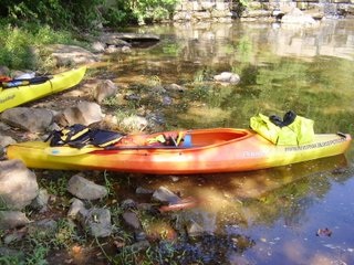
On the bow of my boat, seen in this picture, is a dry bag with all the food I will have for the trip (minus a bag of M&Ms and a Dr. Pepper that I will acquire later on), along with three gallons of water, my sleeping bag, a pair of flip-flops and assorted odds and ends that I tossed in there along the way.
At 11:30 a.m. we put in below the Woolen Mills dam (which was breached one year later) on the Rivanna River and began our adventure to Richmond.

The Rivanna River was flowing very well. Ruins from the Rivanna’s trade route days could be spotted along the banks and under the water. Remnants of wing dams, hydropower dams for mills, canals, towpaths, and locks can still be seen along the Rivanna from Charlottesville to Columbia.

At about 16 miles from our put in, near Palmyra, two public camping areas were marked on the map. The first one was on an island and the second was on the right bank, past the island. We stopped at the island, which had obviously been camped on (LNT hasn’t made it this far, I guess), and stayed the night.
Come back next week for Part 2.
No comments:
Post a Comment