Thursday, August 29, 2013

One Student’s Journey Down The James


Have you ever wondered what it would be like to travel down the James for 8 days straight?

Zach Perkins, a rising senior at the Clover Hill Math and Science High School wrote a first-hand account of his journey on the middle James with the James River Expeditions which can be seen in the Midlothian Exchange.

“No electricity, no air conditioning, no showers.

These were the conditions that nine fellow students, five adult leaders and I had to experience for eight days. But, you will not hear any complaints from this group! Rather, all we have to share are stories that will last us a lifetime.

In mid-July, a group of 10 students and five adults set off on an expedition down the Middle James River. Sponsored by Dominion Power and the James River Association (JRA), we spent eight days canoeing, camping, and experiencing the beauty of the James River.”

Read the full story here…

Tuesday, August 27, 2013

Secrets of the James - The Importance of Oysters

by Justin Doyle, JRA's Outreach Manager

“The bottom of the James River is one enormous oyster-bed,” wrote a New York Times reporter who sailed with an oystering schooner in 1880. “From its mouth for 20 miles up, it is nothing more or less than a natural oyster-bed. Go anywhere in it you may and push to the bottom a pair of oyster-tongs, bring them together, and lift them out of the water, and you will catch oysters.”

Native Eastern Oysters (Crassostrea virginica) were once prevalent in the James River and Chesapeake Bay. According to the National Oceanic and Atmospheric Administration Chesapeake Bay Office, oyster populations in the Chesapeake Bay today are less than 1% of their historical populations. The steep decline in population is attributed to poor water quality, disease (MSX and Dermo), and over-harvesting. Poor water quality stresses oysters making them more susceptible to disease.

Fortunately, oyster restoration efforts are underway throughout the Chesapeake Bay Watershed. Virginia recently launched the largest oyster replenishment effort in its history. Oyster shells mined beneath the James River near Jamestown are being used to create habitat in areas of the river where oysters have historically grown. According to Natural Resources Secretary, Doug Domenech, "Oysters in Virginia are about an $8 million business now, and in fact last year we harvested the most oysters since 1989.”

Not only are oysters economically important, they are ecologically important to water quality. Oysters are filter feeders, which means they filter their food from the water as they feed. It is believed historical populations were able to filter the entire Chesapeake Bay in a week! It takes the current population about a year to filter the entire bay.

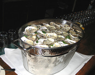
SLURP! Have you ever tried a flight of raw oysters? If you haven’t and you like oysters, you should. The flavor of an oyster varies depending on where it is harvested. Oysters harvested from Virginia rivers like the James and Rappahannock are less salty than oysters harvested from Chincoteague Bay, located on Virginia’s Eastern Shore. On a recent visit to Richmond’s Rappahannock restaurant, an outpost of Rappahannock River Oyster Co., I compared the flavor of an oyster raised in the Rappahannock River to one raised in the Chincoteague Bay. After slurping each oyster down my gullet, their unique flavor profiles became evident. The Rappahannock had a mild almost buttery flavor compared to the Olde Salt from Chincoteague Bay, which was briny. I highly recommend the experience!

Sources:
“Oysters of the James” New York Times article from the May 16, 1880: http://query.nytimes.com/mem/archive-free/pdf?res=9800E4D7173FEE3ABC4E52DFB366838B699FDE

“Oyster Shells on the Move” Public News Service article from the July 9, 2013: http://www.publicnewsservice.org/index.php?%2Fcontent%2Farticle%2F33377-1

Oyster Restoration – National Oceanic and Atmospheric Administration Chesapeake Bay Office:

Oyster Reefs - National Oceanic and Atmospheric Administration Chesapeake Bay Office

Monday, August 26, 2013

From Homely to Healthy in One Summer: Part 1- The Plan

By Linda Mills, River Hero Homeowner

            Recently our yard was transformed from an urban lot plagued with water problems into a river-healthy patch of natural beauty that attracts birds, butterflies and humans in equal droves. We always knew our yard had issues—run off and flooding being the most critical. And we had attempted to “fix” it with a rain barrel and grading the land toward the alley, away from our house. But with the amount of roofline we have, rain water still found its way into the alley, the street and our basement.

            About a year ago, Alliance for the Chesapeake Bay was promoting a program to address stormwater pollution in the Reedy Creek Watershed of South Richmond. Since we live in this watershed which flows into the James River, our home was eligible for a free audit conducted by Alliance for the Chesapeake Bay and the Reedy Creek Coalition. As a River Hero Home certified by the James River Association, we were interested in continuing our dedication to the James River. We already had some of the required river-friendly practices in place—utilizing a rain barrel, picking up after our dog, and eliminating fertilizers by using compost from our own compost pile. But we wanted to do more.

            The volunteers and experts from Alliance for the Chesapeake Bay came and studied our yard. They identified where we could improve the landscape to decrease run off, and they made recommendations on how to accomplish this. The final report gave us several options. First, we could install a rain garden in an area that was a route to the street for roof run off. Second, we could create a BayScape of native plants as a buffer to slow run off. Finally, we could solve one of our property’s most serious run off problems by installing permeable pavers. Each option sounded great, and we wanted to do all three. But who has the money for all those improvements? The Alliance for the Chesapeake Bay did!

            Alliance for the Chesapeake Bay had received grant funding from the National Fish and Wildlife Foundation, The Community Foundation, and Altria to help homeowners in the Reedy Creek Watershed reduce their stormwater runoff. Since we qualified for improvements recommended by the audit, our yard qualified for grant-funded projects, as long as we adhered to their requirements. We were thrilled!

             “Let’s get started,” we cried!

            The first step was to choose a landscaper. Alliance for the Chesapeake Bay had a list of approved landscapers, folks who had been trained to understand the importance and logistics of rain gardens, BayScapes and permeable pavers. Having been impressed by several of their projects in the neighborhood, we chose Greener Landscapes, a local team of three tremendously hardworking guys led by Ian Johnson (804-339-4401, ian@greenerlandscapes.com). We could not be more delighted with our choice. (And at this point, our neighborhood boasts several impressive river-friendly gardens this team has created.)

            Ian met with us to find out what we liked and hoped for, studied the yard, and then drew up plans. (We paid for the plans.) He presented us with a gorgeous rendition of what our yard could look like, including all the wonderful native plants he suggested using, their common names and their Latin names. We knew many of the plants—purple coneflower, black-eyed Susan, and bee balm. But what were black snake root, service berry and Virginia sweetspire? We took our own research trip online with that list in hand. It was exciting to find out about plants that would thrive in our Virginia yard.

            After fiddling with the plans and plant choices a bit, the whole plan had to be approved by Alliance for the Chesapeake Bay. Once we were given the go ahead, we went! Here are some photos of our yard before anything was done. We so needed a makeover! Stay tuned for additional coverage of our new yard. You can look forward to photos of each stage of the rain garden, the BayScape and the permeable pavers as they went in.

 Find out how this…


…turned into this!


 And how this area became a beautiful and functioning rain garden!


Next installment: From mud pit to rain garden!

Thursday, August 22, 2013

New Beer Garden at James River Brewing Highlights Scottsville’s Mink Creek

by Amber Ellis, JRA's Watershed Restoration Associate/Volunteer Coordinator


 View of Mink Creek in Winter 2012

Last fall, Chris Kyle with James River Brewing in Scottsville, spoke to Pat Calvert, JRA’s Upper James Riverkeeper, about the brewery’s plan to expand their tasting room outside and wanted JRA’s opinion on how to do it the right way. Mink Creek, a tributary of the James River, flows right behind their building and at the time there was no buffer along their side of the creek. But that was about to change!
  
JRA’s Landscape Architect, Amber Ellis, designed a riparian buffer that incorporated plants that are native to Albemarle County. Not only are they native, but a few of them are even edible! The brewery staff has already made delicious cobbler out of the fruit from the Juneberry (Amelanchier lamarckii) and Mountain mint (Pycanthemum muticum) is great used as a tea. While natïve Hophornbeam (Ostrya virginiana) is not edible, the fruit resembles the fruit of the hops plant that is used to make beer.
   
  The Hophornnbeam tree in its new home with a hedge of Winterberry along the creek and Juneberry in the background. Taken on May 9, 2013 during the installation.
On May 9, 2013, JRA led a group of volunteers, including four of JRA’s RiverRats, brewery staff, and several folks from the community to install the plants. The James was at flood level that day, but Mink Creek was fine.

 Volunteers after a hard day’s work.
This wet and mild summer has been the perfect environment for the plants to get settled in and they are all doing great! JRA developed three educational signs that were installed this summer that teach visitors about native plants, the history of the building, and about the Mink Creek watershed. The beer garden has become a gathering place for the community and brought attention to this wonderful little creek that is tucked behind the buildings in town. There are plans to run a trail along Mink Creek in the future with a small bridge at the beer garden for folks to hop off and take a beer break. People can be found drinking coffee there in the morning and in the evening enjoying a beer with the sounds of live music.
   

Joe-Pye Weed, Black-Eyed Susan, and Mountain mint in full bloom in August 2013.


 If you are ever in Scottsville, stop by the James River Brewing Company to enjoy a beer in a beautiful garden along Mink Creek.
Visit the James River Brewing Facebook page for upcoming events and for more photos of the Beer Garden.  

Wednesday, August 21, 2013

The Tire-Less James - The Numbers Are In!

Thanks to volunteers from Virginia Canals & Navigations Society, Heart of Virginia Council Boy Scouts of America, the crews of six The James River batteaux, some JRA RiverRats and a host of other volunteers, the James is now tire-less!

On Saturday, August 17, 154 volunteers took to the river in boats of all kinds as part of the first Tire-Less James event and together they removed 479 tires from a 59-mile stretch of the James River between Lynchburg and Richmond.

A big thank you also goes to Bridgestone Americas LLC’s "One Team One Planet" Spent Tire Program, for providing free hauling and recycling of all the tires that were collected.

If you are interested in participating in next year’s event you can sign up to volunteer, select the Tire-Less James event in the interest section, and we will send you information as next year’s event gets closer!


These photos were taken by volunteers during the event. See all the fun they were having on our facebook album

Tuesday, August 20, 2013

Conservation Tips - Mowing 101

by Amber Ellis, JRA's Watershed Restoration Associate/Volunteer Coordinator

There’s no right or wrong way to mow your grass, right? Wrong! By following a few guidelines, you will reduce stress on your lawn, plus reduce watering and fertilizing needs. Native garden beds and forests are great for water quality, but a dense, healthy lawn can also stop pollutants and nutrients from entering our waterways.

3 Mowing Tips:

1) Mow high. Make sure the blades on your mower are sharp and mow high so that you have 2-3 inches of grass. Generally speaking, what you see on top of the ground is an indication of how much is under the ground.  In other words, taller grass has a more developed root system that will more efficiently capture water and nutrients.

2) Mow often. The general rule of thumb for mowing is not to remove more than 1/3 of the height of the grass.  If the grass has become too tall, you will need to mow more frequently and gradually lower the mowing height of successive cuttings, following the 1/3 rule.

3) Leave the clippings! Finally, make sure that clippings aren't on the sidewalk or street so they can’t wash into storm drains, but don’t bag them!  Leave clippings on your lawn so that they can act as natural fertilizer.

For more mowing tips visit Mow Like a Pro.

Thursday, August 15, 2013

JRA Constructs Experimental Spawning Reef to Benefit Endangered Atlantic Sturgeon

During the week of July 22nd, Coastal Designs carefully placed 2,700 tons of rock in the  James River just downstream from the Varina-Enon Bridge to form a 70-foot by 300-foot by 2-foot high mound on the river bottom. This artificial reef will provide the type of hard, rocky surface that Atlantic sturgeon and other native fish require to lay their eggs. It also provides a safe place for young hatchlings to escape predators.

Centuries of agriculture and development along the length of the river have changed the river bed, adding silt that has obliterated much of the river’s once rocky bottom, degrading the sturgeon’s spawning habitat. It is hoped that by providing an ideal spawning habitat, such as the rocky reef, scientists will have a better chance to study the river giant and help them rebuild their local population. 

Representatives from Luck Stone, who donated the rock, The Nature Conservancy/ NOAA and U.S. Fish and Wildlife Service, who helped fund the project, members of the press and JRA staff members watched as a skilled equipment operator scooped up shovels of rock from a barge and carefully placed them on the river bed in a strategic egg-crate design of hills and valleys.  The site for the reef was chosen because it had the optimum water flow and amount of dissolved oxygen in the water for sturgeon. This represents the third experimental spawning reef built in the James since 2009.

The timing of the construction is ideal, as Atlantic sturgeon have recently been seen in the lower James in advance of the autumn spawning season. No sturgeon sightings have yet been reported in the reef area of the river, which may be due to the summer’s elevated rainfall and water temperature. Scientists from VCU and Virginia Department of Games and Inland Fisheries are currently using passive receivers stationed throughout the lower James River to track approximately 125 Atlantic sturgeon that were tagged in the James.


If there’s a “poster child” for the cause of a healthy James River, it has to be the Atlantic sturgeon. After being considered at risk for many years, in 2012 they were placed on the federal endangered species list. While some people call this armor plated fish a living fossil, he’s actually an extraordinary adapter. The dinosaurs with which he swam are gone. In the James River his population was decimated by overfishing and his habitat was degraded by pollution. Yet, every spring and fall, the James River’s Atlantic sturgeon return to spawn. And the fish that was once through to be extirpated from the James may slowly be growing in number, thanks to the hard work of a lot of dedicated people…and a lot of rocks!

Tuesday, August 13, 2013

Wildlife of the James - The Blue Crab


“There are crabs here?”
That’s the typical response during an eco-paddle trip when we find a blue crab in the James River just a few miles downriver of Richmond. The Blue crab, symbol and economic bastion of the Chesapeake Bay, can be found throughout the lower James, particularly in dry summer months.  Male crabs are known to explore fartherr up the James than females, who prefer the salty depths in the middle of the Bay. The Blue crab, having fascinated and fed us well, bears a scientific name meaning “delicious beautiful swimmer.” 
A few important facts about Blue crabs; they:
  • are a vital predator and prey item in the aquatic food chain
  • eat just about everything from fish to shellfish to vegetation to other crabs 
  • are eaten by oysters, menhaden, striped bass, drum, and many birds at different stages in its life cycle 
  • thrive in underwater grass beds that provide shelter for young and for molting and mating
  • have three pairs of walking legs, one pair of swimming legs, and a pair of formidable claws (the males are blue while the females have red tips)
  • mate after the female molts through her final “soft-shell” phase, during which the male cradles and protects the female
  • go through a planktonic larval stage in which they drift towards the ocean before they mature and swim back towards the Bay and its rivers
  • have been severely set back as a species by overharvesting, pollution, and the loss of aquatic grasses.


However…throughout the Bay, the Blue crab population appears to be rebounding as a result of stringent harvest restrictions. That’s great news for this fishery, which is worth over $24 million a year in Virginia alone.
Be careful what you eat.
Recently Virginia Commonwealth University researchers have found Blue crabs with high levels of microcystin, a liver damaging toxin produced by Cyanobacteria, or blue-green algae. The study is being conducted in the tidal, freshwater section of the James from Richmond to the Chickahominy River influx. The researchers are trying to determine whether the high toxin levels are constant or only high during the time of year when the river has large blue green algae blooms. Although the toxins levels found in the Blue crabs are high, these toxins do not stay in shellfish tissue for more than a few weeks. Low toxicity levels were also found in menhaden and blue catfish; however, researchers are unclear on why the levels are so high in the Blue crab.
Cyanobacteria is believed to be caused by nitrogen and phosphorus ‘runoff’, or pollution that is washed off  streets, fertilized lawns and gardens into our waterways. In the worst cases an algae bloom can cause a ‘dead zone’ where it removes all of the oxygen in the water, suffocating aquatic life in the area.
Very little Blue crab harvesting takes place in the freshwater region of the James. The majority of the commercial harvesting takes place in the lower James where the salinity is higher, and presumably the toxin levels would be lower.
Researchers believe that microcystin found in the James is not a risk to humans, but they hope to learn more about the effect of the toxin as the study progresses.


Monday, August 12, 2013

Paddling The Falls of the James

by Justin Doyle, JRA's Outreach Manager

Paddlers residing in RVA are fortunate to have the James River flowing through their backyards. One of the most exciting sections of the river to paddle, The Falls of the James, begins just west of the city limits. In this section, the river drops more than one hundred feet over the course of seven beautiful miles as it enters the coastal plain. Three popular routes offer paddlers of all experience levels the opportunity to enjoy this unique section of the river: Huguenot Woods to Pony Pasture, Pony Pasture to Reedy Creek and Reedy Creek to 14th Street.

Huguenot Woods to Pony Pasture is a flatwater paddler’s delight but be prepared to portage when approaching Williams Dam, also known as “Z-Dam.” The river flows through a fish passageway in the dam and terminates in a dangerous hydraulic where numerous people have drowned over the years. After portaging the dam, continue paddling to the Pony Pasture takeout (river right).

Pony Pasture to Reedy Creek is a fantastic paddle for intermediate paddlers looking to paddle relatively harmless rapids. This route is also a perfect warm-up paddle for experienced paddlers continuing on to the larger rapids downstream. Upon putting in at Pony Pasture (river right), paddlers will be immersed in Class I-II rapids which flow into a tranquil flatwater section. Take time to enjoy the natural beauty around you before approaching Choo Choo (Class II) from the left side of the river. After getting splashed by Choo Choo, immediately return to the right side of the river and paddle under the Boulevard Bridge, also known as the Nickel Bridge. Enter Mitchell’s Gut (Class II) in the center of the river and begin looking for a large sign with an arrow pointing in the direction of the Reedy Creek takeout (river right).

Reedy Creek to 14th Street is a popular route for experienced paddlers seeking the thrill of Class IV rapids. This route begins on Reedy Creek, a tranquil creek that enters the James River just west of Belle Isle. After entering the James River, enter First Break rapids (Class II) through a break in the Hollywood Dam then paddle alongside Belle Isle through Approach Rapids (Class II) to Hollywood Rapids (Class IV). Enjoy the cheers from spectators on Belle Isle as you paddle through Hollywood. After passing under the Belle Isle pedestrian bridge, paddle towards the entrance of Pipeline (Class IV) on the left side of the river. Class III rapids lead to Pipeline, a popular spot for surfing and playing. The 14th Street takeout is just downstream of Pipeline (river left).


Be sure to check river conditions before embarking on a trip! Life jackets must be worn when the river is flowing above five feet at the Richmond-Westham Gauge. Contact the James River Association’s Outreach Manager, Justin Doyle, at jdoyle@jrava.org for more information.

Friday, August 9, 2013

The Anthem James River Splash & Dash in Lynchburg


Over 100 participants and volunteers took part in the 2013 Anthem James River Splash & Dash in Lynchburg on Saturday, August 3, at Percival’s Island.

We could not have asked for better weather or for a more enthusiastic group of participants. One of the participants, Darrell Wargo, said, “ We have all of these running races, but nothing like this...It’s nice to have something different in this town.”

The event took place in downtown Lynchburg, at Percival’s Island. Participants started the race by running across the access bridge, up and down Blackwater Creek Trail, and then on a trail course, until reaching the tubes at the furthermost point of the island. They grabbed their tubes, paddle about a 1/3 mile stretch up river, exited the water and then headed to the finish line.

The overall male winner was Victor Ferguson with a time of 15:26 and the first female to make it across the line was Olivia Deddens with a time of 17:55. The full results are posted on our website.


Special Thanks to LuAnn Hunt Photography for taking photos of this year’s event.  You can view them and purchase any you like at: luannhuntphotography.zenfolio.comLuAnn will donate 20% of all purchases to JRA.

This event would not have been possible without the Lynchburg Splash & Dash Committee, a group of dedicated volunteers from the Lynchburg area.  Special thanks also to Lynchburg Fire and Rescue for being on the land and water for the event. 

We hope that you will plan to join us for our 2014 event!


Thursday, August 8, 2013

The James River Expedition Experience

By Kyle Burnette, JRA Field Educator

Amazing, awesome, unforgettable, life-changing were all words that were used by students and staff alike after each successful completion of this year’s 2013 James River Expeditions. It seems like just yesterday the staff here at the James River Association were pulling out gear from our storage locker in preparation for the beginning of this year’s Expedition. Then, in a flash it seems, exactly six weeks to the day, we had completed 290 miles of The James River with thirty High School students from seven different high schools all located within the James River watershed.

This was the third summer that JRA has conducted the James River Expeditions, along with the generous contributions and support of the Dominion Foundation. The James River Expeditions make it possible for high school students within the James River watershed to take part in an eight-day canoe paddle and camping trip down one of the three sections of the James River. These expeditions immerse students in the rich natural history, ecology and environmental issues facing the greatest natural resource for the state of Virginia.


This year’s Expedition started on Saturday June 22 in Iron Gate. This is the area where the river begins, with the Cowpasture and Jackson Rivers coming together to form the headwaters of the mighty James River. The Expedition on section of the James, known as “The Upper,” consisted of a total of ten high school students from Hopewell High School, Jamestown High School and Hickory High School with a teacher from each school accompanying the students. Each section of the Expedition is also led by four James River Association educators. The “Upper James River Expedition” team or UJRE for short, spent the next eight days paddling the narrow waterways of Albemarle and Botetourt County. Finally, concluding their journey eight days later on the famous Class III section of whitewater known as Balcony Falls.


The next team of “Middle James” Expeditioners was supposed to begin their journey on Saturday, July 13 in Lynchburg. With all of the water that the state has experienced over the spring and early summer months water levels were too high to put on the river in this section. We decided on a backup plan of giving the students from Monocan and Clover Hill High School in Chesterfield County a chance to see where the James River begins farther upstream. After a few days of allowing for water levels to get back down to a safe level, we were back on schedule by Monday and paddled from just downstream of Lynchburg all the way to Cartersville.

The final leg of this year’s Expedition team began their paddle in Richmond on Saturday, July 27 with a rafting trip of the technical fall line in the heart of Richmond, courtesy of Riverside Outfitters. The final stretch known as the “Lower Section” traveled from Richmond all the way down to where the James River feeds into the Chesapeake Bay at Hampton. There were three high schools represented on the Lower James Expedition all coming from different areas of the state.  This included students from James River High School in Botetourt County, Highland Springs High School in Henrico County and Woodside High School in Newport News. This team completed their paddle on Saturday, August 3 at Fort Monroe in the Chesapeake Bay. With this accomplishment, this team wrapped up this year’s James River Expedition and are now part of a group of thirty high school students from seven high schools from all across the state that can say they have paddled the entire James River from the very start at the headwaters to the very end at the Chesapeake Bay.

The experiences, knowledge and leadership skills each of these thirty students took away from this year’s Expedition will have long lasting positive effects. The stories of each Expedition team can be found on JRA’s Facebook and Twitter pages and the James River Association website. I highly encourage you to take a look back at the experiences of these students and hopefully this will encourage you to become a steward of this incredible natural resource, the James River.    

Tuesday, August 6, 2013

Top 5 Tubing Spots Along the Middle James

by Amber Ellis, JRA's Watershed Restoration Associate/Volunteer Coordinator

It’s been a wet start to the summer, but things looks like they are finally getting back to normal, which is music to river lovers’ ears! A great way to spend a warm summer day out on the river with your family and friends is to go on a tubing trip. Here is a list of some great spots along the middle James recommended by JRA’s RiverRats. These locations are good whether you have your own tube or need to rent one. Have fun and be safe!


View Untitled in a larger map

James River State Park: This is a 2-mile float with a few riffles. It runs alongside the park through rolling hills. The park offers tube rentals and provides a shuttle. Make it a weekend trip and camp or stay in one of their cabins. “Along the way, there is only one or two spots of "swift" water. One of which is at Treasure Island on the right side, a good half way point with a nice beach to take out, relax, stretch, or have a snack. All in all, you can't beat the services and amenities offered by the park, plus that part of the River is great for beginners.”-RiverRat Kevin Hansen

Warren to Hatton Ferry: This is a 3-mile trip that takes you along the James through rural Virginia and is a great easy float. If you do not have your own tube, James River Runners offers tubes and shuttles. “Warren has a nice sandbar with eddies that make a nice swimming hole and lunch spot. If Hatton is your pickup there is a set of class 1 and you'll navigate through a riverwide rocky outcrop. Fun stuff.”-RiverRat Chad O’Brien

Hatton Ferry to Scottsville: This is a 4-mile trip along the James that is a pretty calm float. If you do not have your own tube, James River Reeling and Rafting offers tubes and shuttles. If you have time after tubing, take a little walk through Scottsville, a great little river town! Horseshoe Flats is a great place to camp if you want to make it a weekend trip.

Cartersville to West View:  Enjoy a 5-mile float that is mostly flat with a couple of riffles. You will need to provide your own tube, but there is parking at Cartersville and West View. “I would recommend Cartersville to West View… We have enjoyed the float with family on 4th of July several times.” –RiverRat Roy Hyle

Powhatan State Park to Maidens: Come out to visit Virginia’s newest State Park on the banks of the James! This float is about 5 miles and is mostly flat with a stretch of big boulders and deep water. You will need to provide your own tube, but there is parking at the park and at Maidens landing.

There are also great spots on the Upper and Lower James, but that would be just too big of a list! For more recomendations along the James and throughout Virginia, visit http://www.virginia.org/directory/outdoorsandsports/raftingtubing/

Friday, August 2, 2013

The Tire-Less James

Help to make the James Tire-Less!
JRA is partnering with Virginia Canals & Navigations Society and the Heart of Virginia Council Boy Scouts of America in The Tire-less James project on August 17
Volunteers are needed to remove tires from the James River between Lynchburg and Richmond during the first Tire-less James Event.
Bridgestone Americas LLC is supporting JRA's efforts by providing free hauling and recycling of all tires collected during the cleanup through its "One Team One Planet" Spent Tire Program.
The TireLess James
Thank you to the James River batteaux that will be helping to collect and remove tires: Rose of Nelson, Anthony Rucker, Clifton Lee, Slate River, Roselea or the Fine Creek Mill.